Top 10 longest sea bridges (Bridge section only) in the world.
This list only includes cross-sea bridges. Inland river bridges and lake bridges are not included.
This ranking is based on the Bridge section length, Excluding the tunnel and land part of the bridge. Bridge section length represents the true length of the bridge project.
The list will automatically update in real-time to maintain the list’s accuracy.
10Incheon Bridge

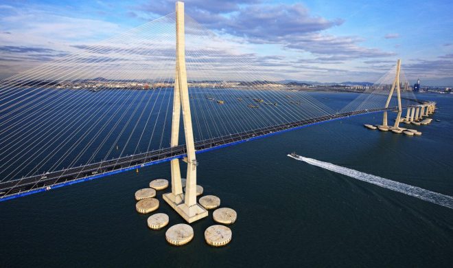
Incheon Bridge Located in Incheon, northwest of South Korea, it is a cross-sea bridge connecting Yeongjong Island and Incheon. It crossed the Yellow Sea.
The length of the bridge is 13.3 mi (21.4 km ), the Bridge section length is 11.4 mi (18.4 km ), and the Length over water is 7.3 mi (11.7 km ). It started construction on July 1, 2005 and opened on October 16, 2005. The bridge cost 2300 billion won (about US $2 billion).
Incheon Bridge Data
- Country
- South Korea
- Region
- East Asia
- Status
- In use
- Official name
- 인천대교
- Location
- Incheon, South Korea
- Contractor
- Samsung C&T (Daelim, Daewoo, GS, Hanjin, Hanwha, Kumho)
- Designer
- Samsung C&T (Daelim, Daewoo, GS, Hanjin, Hanwha, Kumho)
- Official website
- incheonbridge.com
- Maintained by
- KODA Development
- Cost
- 2300 billion won (about US $2 billion)
- Began
- Jul-01, 2005
- Opened
- Oct-16, 2005
- Total length
- 13.3 mi ( 21.4 km )
- Tall (tower)
- 782 ft ( 238.5 m )
- Length over water
- 7.3 mi ( 11.7 km )
- Bridge section length
- 11.4 mi ( 18.4 km )
- Width
- 110 ft ( 33.4 m )
- Deck height
- 243 ft ( 74 m )
- Longest span
- 2625 ft ( 800 m )
- Design type
- Cable-stayed bridge
- Road scale
- 6 lanes
- Crosses
- Yellow Sea
9Quanzhou Bay Bridge

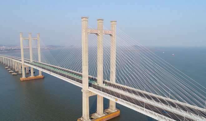
The Quanzhou Bay Bridge is located in Quanzhou, Fujian Province, China, on the Quanzhou Bay.
The Bridge started construction on December 31, 2009; the closure project was completed on June 30, 2014; and it opened to traffic on May 12, 2015.
Quanzhou Bay Bridge connects Shishi City and Hui'an County. The total length of the bridge is 16.6 mi (26.7 km ), the Bridge section length is 12.6 mi (20.3 km ), and the Length over water is 7.7 mi (12.5 km ). The main bridge deck on the sea is a two-way eight-lane highway with a design speed of 100 kilometers per hour.
It total cost 6.9 billion yuan (US $1 billion ). Design life is 100 years.
Quanzhou Bay Bridge Data
- Country
- China
- Region
- East Asia
- Status
- In use
- Official name
- 泉州湾大桥
- Location
- Quanzhou City, Fujian Province, China
- Operator(s)
- Quanzhou Bay Cross-sea Bridge Co., Ltd.
- Cost
- 6.9 billion yuan ( US $1 billion )
- Design life
- 100
- Began
- Dec-31, 2009
- Construction end
- Jun-30, 2014
- Opened
- May-12, 2015
- Total length
- 16.6 mi ( 26.7 km )
- Bridge section length
- 7.7 mi ( 12.5 km )
- Width
- 12.6 mi ( 20.3 km )
- Width
- 135 ft (41 m )
- Deck height
- 146 ft (44.6 m )
- Longest span
- 1312 ft (400 m )
- Design type
- Cable-stayed bridge
- Toll
- 2.8 yuan ( US $0.3 ) / km
- Design speed
- 100 km / h
- Road scale
- 8 lanes
- Crosses
- Quanzhou Bay
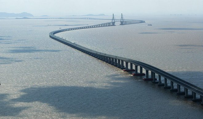
8Jintang Bridge

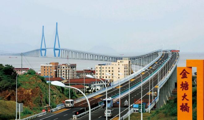
Jintang Bridge is above the gray turtle ocean in the East China Sea.
It connects 3 places in Zhejiang Province, 1: Zhoushan City, 2: Zhenhai District, Ningbo City, 3: Jintang Island. It is one of the important components of the "Zhoushan Cross-sea Bridge" project.
The construction of the Jintang Bridge started on September 30, 2005; the closure of the main bridge was completed on June 25, 2008, and the entire bridge section was fully connected; it was opened to traffic on December 25, 2009.
The total length of Jintang Bridge is 16.5 mi / 26.54 km, Bridge section length is 13 mi / 21 km, And length over water is 11.4 mi / 18.4 km. The bridge deck is a two-way four-lane highway with a design speed of 100 kilometers per hour. The total investment is 7.7 billion yuan (about 1.2 billion US dollars).
Jintang Bridge Data
- Country
- China
- Location
- Jintang Island, Zhoushan/Zhenhai, Ningbo
- Official name
- 金塘大桥
- Cost
- 7.7 billion yuan (US $1.2 billion )
- Status
- In use
- Maintained by
- Zhoushan Bridge Construction Management Bureau
- Began
- Sep-30, 2005
- Construction end
- Jun-25, 2008
- Opened
- Dec-25, 2009
- Total Duration
- 3 years
- Length
- 21 km (13 mi)
- Cross-sea section length
- 18.4 km (11.4 mi)
- Width
- 35 m (115 ft)
- Longest span
- 620 m (2,034 ft)
- Design type
- cable-stayed bridge
- Bridge type
- Cross sea bridge
- Crosses
- Huibieyang sea area(On East China Sea)
- Road scale
- 4 lanes
- Design speed
- 100 km / h
- Toll
- ¥100-395 Yuan(About $14-60) Cars ¥100
7Second Penang Bridge

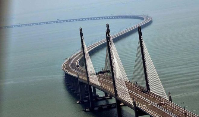
Second Penang Bridge is located in Penang Strait in Malaysia.It also called The Sultan Abdul Halim Muadzam Shah Bridge.It connect the area of Seberang Perai on the Malay peninsula with the island of Penang.
The total length of the bridge is 24 km (15 mi) with length over water at 16.9 km (10.5 mi), making it the longest bridge in Malaysia.It won ICE’s Brunel Medal Award in 2015.
It was largely funded by a loan from China.It was rm 4.5 billion(about US $1 billion ).It is the second bridge to link the island to the mainland after the first Penang Bridge.
Second Penang Bridge Causeway Data
- Country
- Malaysia
- Location
- Penang, Malaysia
- Official name
- Jambatan Kedua Pulau Pinang
- Other name
- Sultan Abdul Halim Muadzam Shah Bridge
- Designer(s)
- Government of Malaysia, Malaysian Highway Authority (LLM), China Harbour Engineering Co Ltd(Package 1), UEM Builders Berhad(Package 2)
- Constructed by
- China Harbour Engineering Co Ltd(Package 1), UEM Builders Berhad(Package 2), MAZELE(Package 3A), IJM Construction Sdn Bhd(Package 3B), HRA Teguh Sdn Bhd(Package 3C), SU Citra Bina Sdn Bhd(Package 3D).
- Cost
- rm 4.5 billion(US $1 billion )
- Status
- In use
- Maintained by
- Jambatan Kedua Sdn Bhd (JKSB)
- Began
- Nov-08, 2008
- Construction end
- Apr-20, 2013
- Opened
- Mar-02, 2014
- Total Duration
- 4.5 years
- Length
- 24 km (15 mi)
- Length over water
- 16.9 km (10.5 mi)
- Width
- 30 m (98 ft)
- Deck height
- 30 m (98 ft)
- Longest span
- 250 m (820 ft)
- Design type
- Cable stayed bridge, box girder bridge
- Bridge type
- Cross sea bridge
- Crosses
- Penang Strait, Malaysia
- Road scale
- 6 lanes(4 for cars / 2 for motorcycles)
- Toll
- RM7-10
- Design speed
- 80 km/h (50 mph)
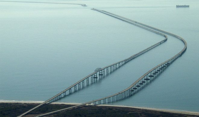
6Chesapeake Bay Bridge–Tunnel

Chesapeake Bay Bridge–Tunnel is a 17.6-mile (28.3 km) bridge–tunnel crossing at the mouth of the Chesapeake Bay, the Hampton Roads harbor, and nearby mouths of the James and Elizabeth Rivers in the U.S.state of Virginia.
The bridge–tunnel originally combined 12 miles (19 km) of trestle, two 1-mile-long (1.6 km) tunnels, four artificial islands, four high-level bridges, approximately 2 miles (3.2 km) of causeway, and 5.5 miles (8.9 km) of northeast and southwest approach roads—crossing the Chesapeake Bay and preserving traffic on the Thimble Shoals and Chesapeake dredged shipping channels leading to the Atlantic.
The original 2-lane bridge-tunnel facility was opened in April 1964, took 4 years to build, and it cost $200 million for planning, design, right-of-way, and construction.After 2 expansions, Chesapeake Bay Bridge + Shoal Tunnel + Trestle total cost US $1.15 billion.
Chesapeake Bay Bridge–Tunnel Data
- Country
- America
- Location
- Virginia Beach and Norfolk, Chesapeake, Portsmouth to Cape Charles, Virginia, U.S.
- Official name
- Lucius J. Kellam Jr. Bridge–Tunnel
- Cost
- Chesapeake Bay Bridge + Shoal Tunnel + Trestle (0.2b + 0.75b + 0.19b = $ 1.15 billion)
- Status
- In use
- Maintained by
- Chesapeake Bay Bridge and Tunnel Commission
- Began
- Oct, 1960
- Opening date
- April 15, 1964 (northbound) April 19, 1999 (southbound)
- Total Duration
- 4 years
- Length
- 23 miles (37 km)
- Bridge section length
- 17.6 miles (28.3 km)
- Deck height
- 75 feet (22.9 m) (North Channel) 40 feet (12.2 m) (Fisherman Inlet)
- Design type
- Fixed link: low-level trestle, single-tube tunnels, artificial islands, truss bridges, high-level trestle
- Bridge type
- Cross sea bridge
- Crosses
- Chesapeake Bay
- Road scale
- 4 lanes (4 on bridges, 2 in tunnels)
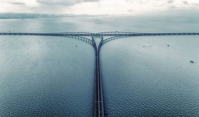
5Jiaozhou Bay Bridge

Jiaozhou Bay Bridge is located Jiaozhou Bay in China. It is a cross-sea channel in Huangdao District, Chengyang District, Licang District and Jiaozhou City in Qingdao City, Shandong Province, China.Jiaozhou Bay Bridge also called Qingdao Bay Bridge.
The Bridge has a total length of 42.23 kilometers and a bridge length of 31.630 kilometers; the bridge deck is a two-way six-lane highway with a design speed of 80 kilometers per hour.
It transects Jiaozhou Bay, which reduces the road distance between Qingdao and Huangdao by 30 km (19 mi), compared with the expressway along the coast of the bay, reducing travel time by 20 to 30 minutes.
The total investment is 9.53 billion yuan (about 1.5 billion US dollars).
Jiaozhou Bay Bridge Data
- Country
- China
- Location
- Jiaozhou Bay, Qingdao, Shandong Province, China
- Official name
- 胶州湾大桥
- Other name(s)
- 青岛海湾大桥
- Cost
- 9.5 billion yuan (US $1.5 billion )
- Status
- In use
- Maintained by
- Shandong Expressway Group Co., Ltd.
- Design life
- 100 years
- Began
- Dec-26, 2006
- Opening date
- Jun-30, 2011
- Total Duration
- 5 years
- Length
- 26.2 miles (42.2 km)
- Bridge section length
- 19.7 miles (31.6 km)
- Width
- 35 m (115 ft)
- Deck height
- 148 ft (45 m)
- Longest span
- Cangkou Waterway Bridge: 260 m (850 ft)
- Design type
- Cable-stayed bridge, suspension bridge
- Bridge type
- Cross sea bridge
- Crosses
- Jiaozhou Bay
- Road scale
- 6 lanes
- Design speed
- 80 km / h
4Donghai Bridge

Donghai Bridge is located in Hangzhou Bay, Zhejiang Province, China. It connects Shanghai and Yangshan Deepwater Port.It is also one of the key supporting projects of Yangshan Deepwater Port (Part of Shanghai Port).
The Donghai Bridge was built on June 26, 2002. On May 25, 2005, the Donghai Bridge was fully opened and a ceremony was held. On December 10, 2005, the Donghai Bridge was officially opened to traffic.
The total length of the Bridge is 32.5 kilometers, the main bridge is 25.3 kilometers, the deck is a two-way six-lane highway, the design speed is 80 kilometers per hour, and the total investment of the project is 7.11 billion yuan (about 1.1 billion US dollars).
Donghai Bridge Data
- Country
- China
- Location
- Shanghai and Yangshan Port
- Official name
- 东海大桥
- Other name
- East Sea Bridge
- Cost
- 7.1 billion yuan (US $1.1 billion )
- Status
- In use
- Maintained by
- Shanghai Chengtou Donghai Bridge Management Co., Ltd.
- Design life
- 100 years
- Began
- Jun-26, 2002
- Construction end
- May-25, 2005
- Opened
- Dec-10, 2005
- Total Duration
- 3 years
- Length
- 32.5 km (20.2 mi)
- Bridge section length
- 32 km (19.6 mi)
- Width
- 31.5 m/103 ft (double bridge), 15.25 m/51 ft (single bridge)
- Longest span
- 420 m (1,380 ft)
- Design type
- Beam bridge with cable-stayed section
- Bridge type
- Cross sea bridge
- Crosses
- Hangzhou Bay(On East China Sea)
- Road scale
- 6 lanes
- Design speed
- 80 km / h
- Toll
- ¥20-45 Yuan(About $3-7)
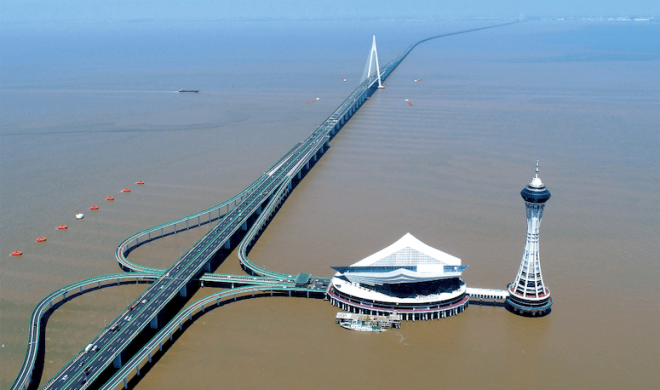
3Hangzhou Bay Bridge

Hangzhou Bay Bridge is located in Hangzhou Bay, Zhejiang Province, China. It is a 36 km (22.4 mile) highway bridge across the sea. It connects Jiaxing City and Ningbo City in Zhejiang Province.
The total length of the Hangzhou Bay Bridge is 36 kilometers, and the bridge section is 35.7 kilometers. The bridge deck is a two-way six-lane highway with a design speed of 100 kilometers per hour.
There is a beautiful artificial offshore platform on the bridge called "Haitian Yizhou", which is located in the middle of the Hangzhou Bay Bridge, 1.7 kilometers south of the South Channel.
The total investment of Hangzhou Bay Bridge was 13.8 billion yuan (US $ 2.1 billion) in 2003.
Hangzhou Bay Bridge Data
- Country
- China
- Location
- Between Jiaxing City and Ningbo City in Zhejiang Province
- Official name
- 杭州湾跨海大桥
- Cost
- 13.8 billion yuan (US $2.1 billion )
- Status
- In use
- Designer(s)
- China Railway Major Bridge Reconnaissance & Design Institute Co., Ltd. (BRDI)
- Maintained by
- Hangzhou Bay Bridge Development Co., Ltd.
- Design life
- 100 years
- Began
- Jun-08, 2003
- Construction end
- Jun-26, 2007
- Opened
- May-01, 2008
- Total Duration
- 4 years
- Length
- 22.4 mi (36 km)
- Bridge section length
- 22.2 mi (35.7 km)
- Width
- 33 m (108 ft)
- Longest span
- 448 m (1,470 ft)
- Design type
- Cable-stayed bridge
- Bridge type
- Cross sea bridge
- Crosses
- Hangzhou Bay
- Road scale
- 6 lanes
- Design speed
- 100 km / h
- Toll
- ¥80-320 Yuan(About $11-43)
2Sheikh Jaber Al-Ahmad Al-Sabah Causeway

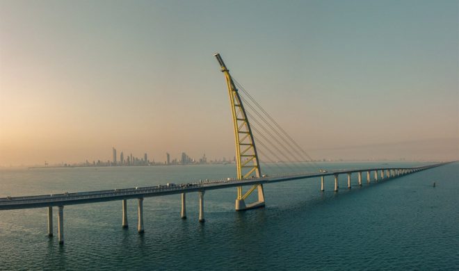
Sheikh Jaber Al-Ahmad Al-Sabah Causeway is located in Kuwait in the Middle East. It is a super sea-crossing bridge built in the Gulf of Kuwait. It connects Kuwait City and Madinat al-Hareer.
The total length of the bridge project is 30.1 mi (48.5 km ). Construction began on November 3, 2013 and opened on May 1, 2019. The construction period is about 4 years. A total of 903 million Kuwaiti dinars (US $3 billion) were spent.
Sheikh Jaber Al-Ahmad Al-Sabah Causeway Data
- Country
- Kuwait
- Region
- Western Asia
- Status
- In use
- Official name
- جسر الشيخ جابر الأحمد الصباح
- Other name
- Sheikh Jaber Al-Ahmad Bridge, Kuwait Bay Bridge, Jaber link Doha Bridge
- Location
- Kuwait City and Silk City, Kuwait
- Owner
- Ministry of Public Works
- Contractor
- Hyundai Engineering & Construction
- Designer
- Systra
- Cost
- 903 million Kuwaiti dinars ( US $3 billion )
- Design life
- 100
- Began
- Nov-03, 2013
- Opened
- May-01, 2019
- Total Duration
- 4
- Total length
- 30.1 mi ( 48.5 km )
- Tall (tower)
- 495 ft ( 151 m )
- Length over water
- 21.7 mi ( 34.9 km )
- Bridge section length
- 23 mi ( 37 km )
- Width
- 56*2 ft ( 17*2 m )
- Deck height
- 75 ft ( 23 m )
- Longest span
- 581 ft ( 177 m )
- Design type
- Beam bridge
- Road scale
- 6 lanes
- Crosses
- Kuwait Gulf
1Hong Kong-Zhuhai-Macau Bridge

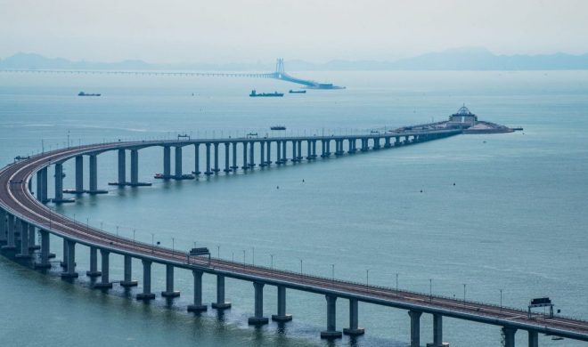
The Hong Kong-Zhuhai-Macau Bridge is a bridge-tunnel project in China that connects Hong Kong, Guangdong Zhuhai and Macau, and is located in the Lingding Ocean area of the Pearl River Estuary in Guangdong Province, China.
The construction of the Hong Kong-Zhuhai-Macau Bridge commenced on December 15, 2009; the main project was completed on July 7, 2017.
The total length of the bridge and tunnel is 55 kilometers, of which the bridge length is 41.6 kilometers, and the main bridge length has reached 29.6 kilometers.The bridge deck is a two-way six-lane highway with a design speed of 100 km / h.
The total investment of the project is 126.9 billion yuan(US $18.8 billion).
Hong Kong–Zhuhai–Macau Bridge Data
- Country
- China
- Location
- Pearl River Delta, Guangdong Province
- Official name
- 港珠澳大桥
- Cost
- 127 billion yuan (US$18.8 billion)
- Status
- In use
- Design life
- 120 years
- Official website
- HZMB Official website
- Began
- Dec-15, 2009
- Opening date
- Oct-24, 2018
- Total Duration
- 8 years
- Length
- 55 km (34 mi)
- Bridge section length
- 25.8 mi /41.6 km
- Width
- 33.1 m (109 ft)
- Design type
- Hybrid cable-stayed, suspension bridge
- Bridge type
- Cross sea bridge
- Crosses
- Pearl River Estuary, Lingding Channel, Jiuzhou Channel.
- Road scale
- 6 lanes


